The Canal Begins to Transform Paddington
The first result of the canal effort was an unfenced basin and a covered unloading shed with a crane and an extended roof to allow barges to be discharged in the dry, but it soon expanded. Under its lease the Canal Company was free to develop an area of 36 acres as it pleased. The Company developed the site as a trading estate with massive warehouses and some modest cottages. In AD 2000, No. 35 North Wharf Road is one remaining example. Listed Grade II, it was to be demolished as part of the new development.
 |
||
| Whole Map | Full Size | Full Size Map in New Window |
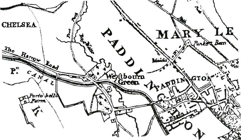
The Faden Map, 1810.
Finding this map was exciting, with the table in the archive room gradually becoming covered in maps, all too early or too late. All the maps showed no canal or both the Paddington Canal and the Regent's Canal. Finally the Archivist produced this Faden map1, still folded in its stiff paper pocket, almost as bright and new as when it was sold to some unknown coach owner five years before Waterloo. It seems to be the only map which shows Paddington Canal without the Regents Canal
Canal trade developed rapidly. Goods came down from the Midlands to eager markets in London to be distributed from Paddington by horse and cart. Soon the area became congested with delivery wagons: rural peace was gone.
Having reached Paddington, the whole canal system became more important to the country. Britain was at war with France. Napoleon's ships frequently raided our coastal shipping, sinking them, or stealing both ship and cargo. Goods were safer by inland canal than exposed to danger at sea. Helped by this, Paddington trade exploded. Indeed barge traffic increased so rapidly that a second basin was planned, parallel to the first. The Map on the next page, shows the proposed basin on what is now Praed Street and the St Mary's Hospital site.
Footnote
- William Faden was a Scotsman, born McFaden, who moved to London and changed his name to avoid harassment from Jacobites and anti-Scottish Londoners. He had a successful partnership with the map maker Thomad Jeferys and inherited the business on Jeferys' death. He was appointed as Geograher in Ordinary to George III. He was selected to publish the Trigonometrical Survey in 1799. Twelve later he published this map of Paddington Canal.
'Map of a Nation' - Biography of the Ordinance Survey
Rachel Hewitt, Granta, 2010, p. 159.
