The Poets Roads had been heavily bombed during the Second World War. By 1945 the houses which were still habitable were in a sorry state and very overcrowded because there was nowhere else for people to live. The Housing Offices had powers to move homeless people into (++)

Milton Grove - east side of the road looking south

1952 OS Map
The Bombsites
To the children who had been born into a world of bombsites, they were the normal world and wonderful playgrounds. By the 1950s other bombsites were being covered with new blocks of flats, but for some reason completely unknown to them, a huge area behind Allen Road, from Wordsworth Road to Milton Grove, was left untouched. They did not know that someone in County Hall had set aside this area, protecting it from the encroachment of houses, storing it like wine to mature for some distant celebration. Over the years more and more people would suggest new, unexpected and creative ways of using this apparent wasteland. It would be there as a developing asset, growing in stages, year by year into the distant future.
In the meantime the children did not reason why, but seized their chance to play on this excitingly territory, and inevitably a turf war arose between the different gangs. As a young boy, Joe Sadler lived in Watson Street. This was a cul-de-sac of old houses off Matthias Road, now rebuilt and far from the huge and enticing playground. Two houses in Watson Street had been bombed and the site barred off behind a fence, easy to climb and soon colonized by children. People dumped their rubbish there but this made it all the better as they could investigate what had been dumped. It was mostly furniture and old TV's with valves, lengths of carpet, corrugated iron, etc. These finds became rocket ships, shelters, and a hundred other things. However, the Watson Street dump was small and not to be compared with the wide acres behind Allen Road.
In Cowper Road, a huge hole in a wall led to this large bombsite. Local children regarded it as their own territory, guarding it jealously. To the Watson Street children it was ‘enemy territory’ but they watched and, when the Cowper Road children were not there, crept through the hole and raced their wooden trolleys made of pram wheels, boards and string, down the exciting slope time and again until they were chased out of Paradise. Today the slope has become the path of the stream.
After the Second World War Joe Sadler was a young boy who lived in Watson Street and played on this huge bombsite which became Butterfield Green. He was an American and when he grew up he went into the United States Air Force where he served for 22 years. When he retired he became interested in the history of his old home and researched the bombing which crated the old bombsite where he used to play.
He reported:-
"The dump I played in was formed thanks to the Luftwaffe! An area surrounding Watson Street received a pasting on the night of 6 November, 1940. The damage included Matthias Road, Balls Pond Road, Tottenham Road School, King Henry's Walk. Judging by the pattern of the delivery, this was all on the same night. The bombs hit in Matthis Road, and crossed into Watson Street. I would say a single bomber did this, with the others attacking Ballspond Road, Dalston and the King Henry's Walk areas on the same night. In 1940, the Luftwaffe used following medium bombers:-
The LCC Fire Brigade reports HE ordinance was used, which would explain the total destruction of the houses, but amazingly only two people were killed. Our back garden in had no room for an Anderson Shelter and no other house in Watson Street had one. I did discover that the family who lived in 37 moved across to 16 Watson St: I think they had family living there. There is no mention of Nos. 37 or 39 Watson Street in any polling books after the war, so the houses n the internet must have been completely uninhabitable. The top part of our house was damaged, but only the roof was fixed. Presumably making the house dry was all they could do at the time." |
For a teacher, the perfect story book to describe this period in the history of Britain is The Otterbury Incident, by C. Day Lewis. Sadly it is out of print at present, but is invaluable as child’s picture of his world at that period, full of adventure and excitement. If a copy can be found it is a good standby.
The Otterbury Incident

Rebuilding
This post-war building effort was frantic, with the different political parties vying with each other to build more ‘housing units’ than the other. Stoke Newington Council began rebuilding blocks of flats and small houses on the bombsites. The tradition of using the names of Poets continued with Binyon, Shelley, Browning, Houses. etc. These rows of flats, maisonettes and small houses were to become Milton Gardens Estate, with its northern limit at the old Right of Way. For centuries there had been a footpath through the fields, and later as series of passageways between the houses, from Albion Road to the High Street. This Right of Way, established over centuries, could not be extinguished so today it can still be traced as an irregular alleyway from Town Hall Path, along the southern edge of Butterfield Green to Spenser Grove, Cowper Road, and Neville Road.
 Milton Gardens Estate

The
start of the Right of Way
Town Hall Path beside Zoom Around, the children’s gym and the site of the Old Town Hall

Spenser
Grove from the Right of Way.

The old Right of Way seen from Neville Road showing the end
of Cowper Road
The 1976 L. C. C. Development Plan
This Plan designated a series of ‘action areas’ where there was need to improve housing and to create small parks as lungs and recreation places. One of these was ‘Shakespeare Walk Action Area’, between Allen Road and the new Milton Gardens Estate. The 1970 OS map shows that the Victorian houses in Spenser Grove had been demolished and small houses built as a secluded enclave, but the old houses on both sides of Cowper Road were still standing at that time.
Public money from the ‘action area scheme’ was used to restore the Victorian houses in the northern end of Milton Gardens. This can be traced from the old and new work on some of the frontages but the internal changes were even more important, converting most into modern self-contained flats.
Building Butterfield Green
Butterfield Green was created in four separate stages over the years as money became available. This is described in detail by Angela Hodgkinson in ‘Finding a Place to Play’, Landscape Design, Oct 1990. What follows is a brief summary of the stages but there is a Link at the end to her complete article.

The Five different parts to Butterfield Green
The Milton Grove square |
Stage 1
The Milton Grove Square
The first area to be developed was a square of ground between Milton Grove and Shakespeare Walk which still contained a few mature trees. Nobody knew if or when further funds would become available so all interests had to be considered; young, old, active and quiet; so a floodlit games area, a lawn, a quiet sitting area with shade and sun, were all created.
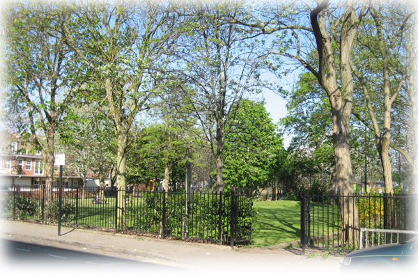
Milton Grove - east side of the road looking south
The Bombsites
This, once again, was the Milton Grove end of the bombsite when it had been cleared. All that had survived were a few trees. It became Phase 1 in the creation of the park.
Milton Grove entrance to Butterfield Green today,
with the
entrance to the Right of Way along the black railings on the right.

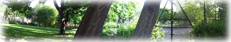
Stage 1 of Butterfield Park in 2008
This picture was taken from the same position as the bombsite one, with some of the new Milton Gardens Estate blocks of flats seen behind the trees.
The
same part of the Green seen ftom the end of Binyon and Shelley houses.
Stage 2 of Butterfield Park
The second area available was at the other end of the park, between Cowper Road and Wordsworth Road. Again the same mixture of areas was created: slide; swings, etc. for play activity - grass for play and also tranquility - and a quiet sitting area. Two patches of land had been created, one at each end of the park, to serve local people, both young and old.
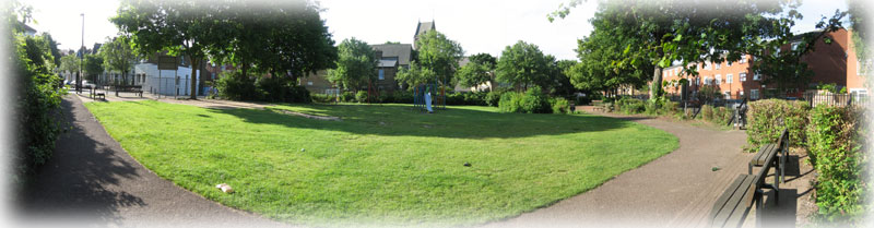
Butterfield Green between Wordsworth Road and Cowper
Road

The edge of Butterfield Green with Wordsworth Road and St Matthias Church behind
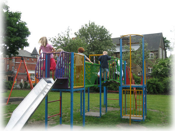
The play equipment in use

The
Cowper Road gate.
The houses on one side of Cowper Road had been demolished for the Green and these small, three-storey houses built.

A
quiet walk opposite the new Cowper Road houses

Cowper Road
On one side of the road are these three storey Houses. On the other is part of Butterfield Green which stretches from Wordsworth Road to Milton Grove.
The Disused church
At this time the Council had also acquired a disused church nearby where the Social Services Department hoped to provide a nursery play facility. In 1990, when Angela Hodgkinson wrote her article on which much of this article is based, the funding for the church conversion had not been found, but since the whole building has been developed.
++Find facts.
Stage 3 in the story of Butterfield Green
The third and largest phase was the creation of Butterfield Green, which involved considerable reshaping of the ground.
Included in this phase were a Bandstand with an area for events and a most unusual wrought iron gate with a cow in a field, a large village green, shaped to a gentle dome which drains well, a woodland walk along the edge of the old Public Right of Way to help link the various parts of the park together, and a maintenance compound and a park keeper’s hut for a mythical park keeper, who was never appointed because of severe cuts to the Park Department’s budget.

The
woodland walk showing The Green, the end of the stream, and the end of Cowper
Road

The Allen Road Gate
These gates weree designed and made by Terence Clerk, a blacksmith artist. They are unusual because they are made of sheets of iron, not bars. The sheets have been cut and pierced into a rolling landscape, with a raised cow feeding under a tree. They are difficult to photograph because they face due north and the roundness of the cow and leaves is flattened out. Perhaps someone will photograph it under strong light angled to bring out the three-dimensional nature of the work. It is a most unusual piece of work.
The Stream
It was decided to build an artificial stream with large rounded boulders edging a shallow brook and a pump to lift the water back continuously to the top of the slope. The natural slope of the land was increased by the new landscaping to create an impressive fall. Granite boulders, rounded by thousands of years of water and frost, were brought to edge the stream. Some of them are over two metres long, heavy, immoveable and with all sharp edges long gone. They form an immense sun-warmed sculpture worthy of some mountain torrent, which invites children to climb, scramble and leap, in unending activity.
This stream was built on the slope where Joe Sadler remembers racing his orange box trolley when the site was still a bombsite, so children’s activity continues on the slope.
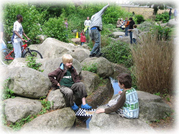
The stream which is edged with huge, smooth stones which the children jump about on.
In the picture above, a plastic duck race is taking place and the children are course stewards, sitting at the winning point ready to award the prize.
The Stream is artificial, but there is a pump which pumps the water back to the top. At the bottom of the slope is a large water chamber with an electric pump in the water. This forces water back to the top through a hose buried beside the stream, so that it can flow down again. The pump was replaced fairly recently, so the system works. Unfortunately cracks have developed in the concrete lining to the stream and the water leaks away. After a period, not enough water returns to the bottom chamber, so the pump must be switched off or it would burn out. The water has been lost and the chamber needs refilling once again. Work needs to be done on the lining before the stream can run regularly. In the meantime, for fairs or other events, the water chamber is filled and the stream runs until the water literally runs out. . When it is switched on, for fairs or other different events, and the chamber has been filled, the organizers can run duck races with plastic ducks. For the rest of the time the stream becomes an enormous climbing and jumping area.

In
this picture the stream has run dry and the boulders edge a dry brook,
waiting
as mountain streams can do, for a torrential downpour.
These huge stones were imported and the stream was built on the slope where Joe Sadler remembers racing his orange box trolley when the slope was still a bombsite.
The New Butterfield Bridge

Butterfield Green Bridge
Photographed in July 2009
Photographs and text by Pat tO’Leary
When Butterfield Green was originally planned a stream, and a bridge over it, was one of the main features of the park. Both had been neglected over the years until 4 years ago when a group of local residents cut back the overgrown vegetation to rediscover the stream and the site of the original bridge (the structure was no longer there). With the help of Hackney Parks, the Learning Trust and Rattlin Boag, a design company, a new bridge was installed and completed in May 2009.
The new bridge is a small suspension bridge. That means the walkway is supported on ropes or cables (this bridge uses nylon rope) which are suspended between the vertical timber uprights positioned either side of the stream. This method of simple bridge building has been used for centuries to cross rivers and streams all over the world. To allow this to happen the timber posts need to be very secure in the ground. Here they are cast into a large concrete foundation buried in the earth. The handrail on both sides is a steel chain again suspended between the timber posts.
All the timber is softwood which is more sustainable than hardwood as it grows faster and so can be replaced quicker. As softwood generally does not last as long as hardwood (it is less durable) it has been treated with a preservative to increase its life span.
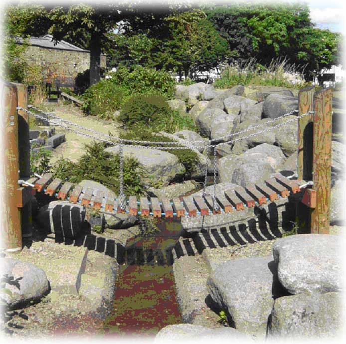
The concrete bases for the old bridge can still be seen
below the new bridge, so it has not disappeared completely.
The Bandstand

The
Bandstand and the events area surrounded with seats

The
Green seen from the end of Cowper Road
Butterfield Green Fair in full clamour
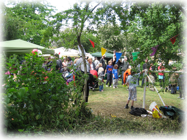
Face painting and a dozen other activities

Tug
of War with the Allen Road behind and the nearer team on the point of defeat.

Preparing
for the Best Dog Parade

The
Dog Show.
All dogs may be entered and it is a hugely popular event,
with the crowd chanting the names of its favourites.

The Butterfield Orchard newly planted with a quiet seating
area facing the sun.

Japanese
stick play
The Adventure Playground in Shakespeare Walk


Adventure City

The
split larch stockade round the Adventure Playground from the end of
Spenser
Grove painted in gentle, muted colours
The Orchard
The Butterfield Orchard newly planted with a quiet seating area facing the sun.
++The development of the old church
++To be researched from 1990 to today.
*****
Information from
|
Butterfield Gardens – the Choice of the Name
24.6.08The Creation of Butterfield Park.doc
last revised: January 2, 2013