Probable Position of the Ice-Sheet During the
Deposit of the Finchley Clay
III.
Is it possible to get a glimpse of England in the Glacial Period at the particular time when the Finchley Chalky Clay was being accumulated? Can we map out in a, general way the physical geography of the country at the time, so far at least as regards this part of England?
Again, Can we represent the probable position of the great ice-sheet, or glacier those terminal moraine supplied the Finchley Glacial Clay?
Strange as it may seem, the affirmative answers to these enquiries can be given with a definite amount of circumstantial evidence. Some of the clues to the state of things in question will now be indicated.
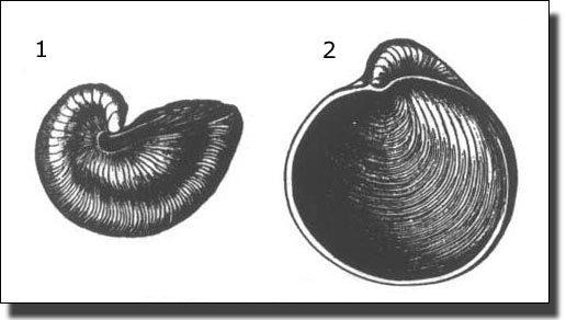
It will be remembered that two particular species of fossil shells are found in great excess of any other material (except the chalk) in the Finchley Glacial Clay. These two species are known as the Hooked Gryphea (Gryphea incurva) and the Dilated Gryphea (G. dilatata). It is principally these shells which give the clue to the district whence the glacial clay was brought to Finchley. We can, in short, point to the probable spot where lay the great glacier whose moraine consisted so largely of these gryphea shells.
It is assumed, then, from this evidence, that the state of things which existed during the accumulation of the Finchley Glacial Clay was such as is shown in the following wood-cut:-
|
Section I. Section across Lincolnshire showing hypothetically the state
of things during the,
Length of section, 35 miles.
|
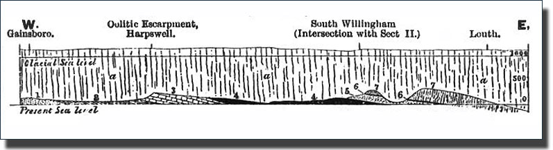
The Land-Ice is shown extending over Lincolnshire from the chalk wold on the east, to the Triassic formation on tile west.
The writer called attention to this fact in Nature August 17th, 1873 (Article, " The Glacial Drifts of North London "), and subsequently brought it to the notice of Mr. Searles V. Wood, junior., who has drawn for him the accompanying section (No. 1), to illustrate the way in which the strata containing these fossils were abraded by the glacier ice so as to furnish material for the Finchley clay.
Among the formations thus covered are the Middle Oolites, the parent formation of the shell Gryphea dilatata; and the Lias, the parent formation of Gryphea incurva; both of which are found in such abundance at Finchley. All the formations shown in the section, and enumerated in the references, inclusive of the red chalk, are represented in the Finchley Chalky Clay; and as the red chalk only occurs in that northern direction, it points, as it were, with singular directness, to this Lincolnshire area as the source of supply.
This great glacier (which there are good reasons for supposing to have been at least a thousand feet in thickness) would thus be the giant plough which was at work upon the rocks of Yorkshire and Lincolnshire, turning out their fossils, and accumulating that moraine profonde which has been spread out in an unstratisfied form over the gravel at Finchley.
A Wider View of the Country During the Glacial Period
A further glance at the condition of England during the Glacial Period, and a wider survey of the area in which glacial remains are found, will still further enlarge our conceptions of the phenomena of the time, and give the greater corroboration to the conclusions which have been arrived at.
Mr. Wood has furnished the writer with tile following section and description, as illustrating his view of the origin of the Chalky Clay, and of the way it was succeeded by tile glacial deposits of the more northern portion of our island.
|
Condensed Section from the Dividing Ridge of the Pennine Chain above Stainmoor, South Eastwards through York to the Chalk Wold at Market Weighton, thence South-South-East to the Lincolnshire Wold Escarpment near South Willingham, and thence Southwards to the North London Glacial Drift Plateau. By S. V. Wood, junior.
1. Paleozoic Rocks from the Silurian to the Permian. 2. Trias. 3. Lias. 4. Various Oolitic formations. 5. Neocornian. 6. Gault. 6'. Red Chalk. 7. The Chalk. 8. Eocene ( London clay, &c.) a The Chalky clay. b The clay without Chalk passing horizontally into b' The Mountain Drift. The figures representing elevation and depression are in feet. |
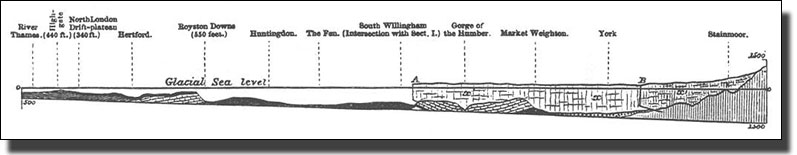
Thus we are shown the general condition of the country along a line from North to South at a particular stage of the submergence of the land beneath the sea. With this pictorial aid, we can comprehend the physical conditions under which the Finchley Drifts originated, and the position they occupy in the great series of similar remains which stretch from our southern lowlands and flats to the far off fells of Westmoreland.
Mr. Walker's Conclusion
This, then, is the chapter in the physical history of England to which the glacial remains at Finchley and Muswell Hill give us the clue. In the light of the remote events of cosmical magnitude which we find so wonderfully attested in these beds of fragmentary rocks and fossil remains, the familiar Middlesex landscapes we have so often looked on may well possess in the future a new and profounder charm. We may learn, too, the practical lesson how little explored is the physical geography of regions which lie almost close to our own doors.
Nor do these relics of the Glacial Period take us back to a time so dim and remote as to be wanting in human interest or in association with man and his fortunes. It will give the greater interest to the scenes and memorials which have just been described if the visitor will remember how comparatively near to the present day the Glacial Period is now found to be. To no remote and ancient geological date does the Age of ice belong. It forms a chapter in the recent physical geography of our country. It may perhaps overlap the early period of man's existence in these latitudes. In the characteristic fauna of the Glacial Period - in the fleece-clad elephant and his companions of Glacial Middlesex, whose remains are found today in tile gravels of the Thames - we behold the contemporaries of Paleolithic man.
Notes by Jack Whitehead in 2008
Mr. Walker was writing about the effect of the Ice Age on Muswell Hill and Finchley. In his very last paragraph he mentions the Paleolithic people who had lived in Britain far earlier, long before this recent Ice Age. At about the same time as he was writing this booklet, important new discoveries about these Paleolithic people were being revealed nearby, in Stoke Newington.
The foundations for new houses being built there and new graves were being dug in Abney Park Cemetery. Both of these were opening up a Paleolithic World four metres below the modern surface and Stoke Newington was becoming one of the most important Paleolithic sites in North Europe. This is described in The Growth of Stoke Newington (now on this website). Thus there were two very different geological periods being explored at the same time in nearby boroughs. The accurate dating of it all would take generations and is still being refined. No wonder it was complicated at the time.
Link to Palaeolithic History in Growth of Stoke Newington
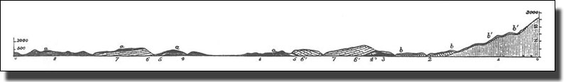
++Page 23 of the Walker booklet consists of a detailed description the longitudinal section of England (Section II above) as it was imagined at that time. It all pre-supposes a large sea to float icebergs and so carry the glacial stones embedded in them southwards. Since there was no such sea and the stones were carried across the land wrapped in the ice sheet, it would be misleading to everyone today to include this page. Anyone interested in the complicated differences between what was thought then and is thought today, can consult the original booklet, but to most of us it would be misleading, so this page has been omitted.
St James's School, which used to be sited in Fortis Green, at the top of the terminal morraine, has been resited further south. Now it is in the valley which was cut each spring by water from the melting ice, sweeping all before it. It flowed to the west in the Dollis Brook to Barnet and to the east to Moselle River and so to the River Lea.
The Modern View
Postscript by Dr. Eric Robinson, Past President of the Geologists Society
While this pamphlet may seem quaint in language to modern tastes, it should be seen as an attempt to convey a vivid impression of the conditions which prevailed in North London suburbs at the time of the Great Ice Age. Henry Walker, a popularizer of Science, might be recognised as a Bellamy or an Attenborough of 1874, intent on taking the scientific facts of the discovery of fossils which were strange to the rocks beneath Muswell Hill or Finchley and accounting for their presence in the strange clays which constantly turned up in the railway cuttings newly opened up in the suburbs, or more frequently, when graves were dug in the new metropolitan cemeteries opened to take the burials from the crowded boroughs of St Marylebone and St Pancras. Apart from fossils which would commonly have been found in the ploughed fields of Lincolnshire ( Gryphea, often known as Devil's Toenails from their thick and wrinkled shell), there were frequent lumps of white Chalk which outcropped at surfaces no nearer than Hatfield.
The power and eroding force of glacier ice was first explained to British audiences at the British Association in 1840, and by 1874, glaciation had been recognised as a popular agency of erosion and transportation of material although active glaciers are no longer part of our experience in this country, even in uplands areas of the Highlands. Instructed by Agassiz, British scientists detected all the evidence of a thick ice cover in the northern hills from which glaciers flowed southwards across the Midland counties. It was just this system which Walker could point to in explaining Chalk pebbles and Lincolnshire fossils in Muswell Hill, building on earlier discoveries of shells in Coldfall Woods by Wetherell as early as 1835, when a glacial cause was quite unknown.
Wetherell was a medical practitioner living on the crest of West Hill who regularly inspected any temporary sections of rock exposed in road cuttings (Archway was one of his best collecting grounds) and well-sinkings for water supply. Along with Caleb Evans of Keats Grove, Hampstead, he represents the keen observers who laid the foundation for our knowledge of the geology of London, a picture so often screened from view by the dense-packed housing as well as the cultivated gardens which go with suburban life. Searles V. Wood, the other expert quoted by Walker was one of the skilled specialists in fossils who spent a lifetime drawing and describing fossils from the younger strata of the South of England. He too lived in Hampstead at this time.
Only one detail of the picture painted by Henry Wetherell would find criticism in any modern account. This was the suggestion that an arctic sea extended south of the actual limit of the ice, a sea in which icebergs floated and dropped foreign stones into a clayey bed. Icebergs were a fascination to Victorian geologists from the accounts brought back by Polar exploration voyages and seemed to offer a compromise to those, such as Lyell, who could not accept fully the eroding power of land ice. In place of the Walker picture, we would now visualise a glacier tongue of very dirty, stone-choked ice, slowly melting and releasing that load of foreign stone in what we now see as the hill bench to the north of Falloden Way and Fortis Green.
Fortis Green was the southern edge of the ice. To the south, Hampstead Garden Suburb south of the Mutton Brook, Highgate Wood and the southern marshland edge of Alexandra Palace, all represent ground which was never overwhelmed by northern ice.
North of that line, however, the situation is different. T.H.Huxley, ' Darwin 's Bulldog' in the famous battle over the Evolutionary Theory, is buried beneath an oak tree in St Marylebone Cemetery, in chalky boulder clay deposited at the southernmost limit of the great glacial invasion from the north. In the soil of the cemeteries, fossils of the kind illustrated by Walker on p. 16 of his pamphlet can still be found when the rain has washed the soil. Each time a grave is dug, the soil can be seen to be charged with pebbles of Chalk, white and soft to the touch. Less frequently, decidedly northern rocks such as lava or granite from as far away as Scotland or Northumberland, turn up in the same fresh clay from Oxfordshire. In this way, the Walker account can be proved anew as good scientific observation. As it stands, however, this pamphlet gives us insight into the scientific thought of the day.
Eric Robinson. 1993.

Cutting through the Hornsey Lane Ridge to build Archway Road
By courtesy of Haringey Archive, Bruce Castle
This was typical of the earthworks being exposed in the Victorian period which gave rise to such intense speculation about the geological history of the area.
