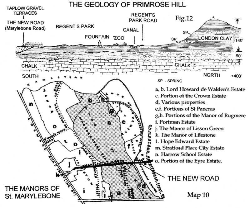
The Geology of Primrose Hill and Marylebone
The New Road (now Marylebone Road) was built precisely at the northern edge of one of the Thames Terraces - sands and gravels laid down by a River Thames of about 250,000 years ago (The Taplow Terrace). The Thames used to flow through the Vale of St Albans, but this became blocked, diverting the river through what is now London.
By Eric Robinson
Over thousands of years the river laid down a wide valley filled with sand and gravel (the Taplow Gravels). This was later bitten into and reformed as a series of river terraces by later events at 125,000, 70,000 and 10,000 years before the present. Each time the river cut a lower terrace and these still control the shape of London. Oxford Street is on the edge of a river terrace and when moving from St Martin's Lane into Trafalgar Square, we move from one terrace to the next lower one.
The Taplow Terraces abut the London Clay of Regent's Park and Primrose Hill. The gravel was ideal for the New Road and also affected the development of St Marylebone in general. The parallelogram of St Marylebone filled up with houses as the gravel gave good foundations, and wells for water. The clay lands were developed later.
 |
||
| Whole Map | Full Size | Full Size Map in New Window |
Diagram by Eric Robonson
The Manors of St Marylebone were taken from a plan dated 1771. Most roads skirt the edges of estates: only the New Road (Marylebone Road) had the authority of Parliament to run in and out of estates. It was the position of the gravel, not the layout of the estates which determined the position of the road.
