Grazebrook Primary School Site in Maps
Years before any of the present Stoke Newington schools were built there were two famous local maps. Stoke Newington was still far out in the country, a land of farms and woodland, with one gravel road called Church Street, joining Stoke Newington High Street and Green Lanes.
The Hackney Brook rose in some streams near our present Grazebrook Road, ran round the northern edge of Abney Park Cemetery and away into Hackney. The ground south of the river was Gravel, while the land north of the river was Clay. Clay is sticky and difficult to build on. Gravel drains well, gives dry walking and allows one to dig wells down to the water below. Therefore Church Street was built south of the Hackney Brook and the gravel land between Church Street and Newington Green was filled with houses long before the builders started on the clay lands to the north.
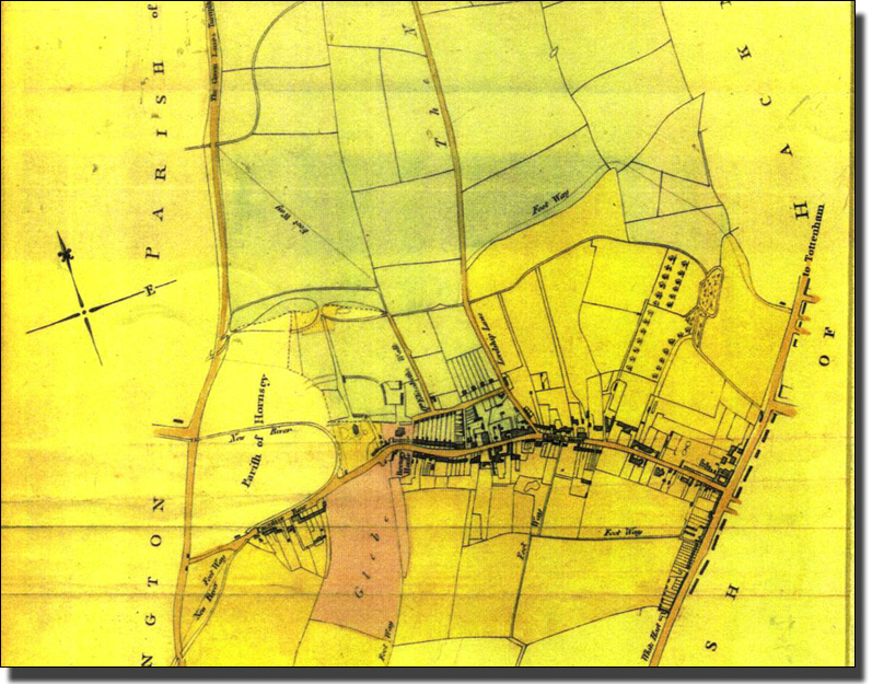
Lady Abney owned a large estate of valuable farmland and woods, north of Church Street. It ran up to Woodberry Down Meadow, near our modern Manor House Underground Station. She had a map made of her estate in 1734.
The Lady Abney Map of 1734

Location of the schools on the
1734 Abney Estate Map
| 1 | Woodberry Down Primary | 4 | Grazebrook Primary School |
| 2 | Site of the Old Woodbery Down Comprehensive A Jewish Primary School called Beis Chinuch (meaning House of Education) now occupies about a quarter of the old Woodberry Down School buildings. |
5 | St Mary's Primary School |
| 6 | William Patten Primary School | ||
| 7 | Betty Layward Primary School | ||
| 8 | Betty Layward Primary School | ||
| 3 | Sir Thomas Abney Primary School | 9 | Grasmere Primary School |
This map was made in 1734 for Lady Abney, who owned the huge estate which stretched from Woodberry Down in the north, to Church Street in the south. She lived in Abney House, and the grounds of her house later became Abney Park Cemetery. In other words, she owned half of Stoke Newington.
At that time it was a land of meadows and hay fields. The style of map making is very old fashioned. The five barred gates are laid out flat. Each field has its local name and size in acres, roods and perches. Today we use square metres and hectares, but this is a very recent change.
This scale of measurement is a follows:-
1 perch = 5¼ yards (which was the length of the whip needed by a ploughman to reach the front ox when ploughing). It then became a convenient length for measuring land. When Lady Abney’s map was made the metre measurement had never been thought of.
The measurement table used in Great Britain
up to about 1960 was as follows:-
1 Acre = 4840 square yards |
Look at the field names and you will see what a rural place Stoke Newington was at that time. How many people today wake up in Woodberry Down to the sound of a lark singing, or have found a wild cowslip growing in the tarmac?
The map was made after the New River had been cut but the reservoirs had not yet been cut in East and West Tile Fields. Lordship Lane still had a large curve in it and one field was called Crooked Lane Field.
Future School Sites on the Earlier Version of the 1734 and 1814 Map
++ FUTURE SCHOOL SITES ON THE EARLIER VERSION OF THE 1734 AND 1814 MAP AND ON THE 1814
The future site of Grazebrook Primary School was in Manor Road at the very top edge of the map. The future sites of St Mary’s and William Patten Primary School were in the High Street. The future site of Stoke Newington Secondary School was in the Vicar of St Mary’s Glebe Field (shown in Pink). The future site of Betty Laywood School was in the bottom left hand corner of the Glebe Field. The future site of Grasmere Primary School was in ‘Parish of’ Hornsey fields’. These were part of Hornsey Removed (Lighter Yellow) which was administered by Hornsey at that time and did not become part of Stoke Newington until 1900 |
++FIND A LATER VERSION OF THIS AND THE MAP
The site of Grazebrook School was probably in Third Croft Meadow. Sir Thomas Abney School was in Wood Land Piece. Woodberry Down Primary School was in South River Field Woodberry Down Comprehensive School, now part of Stoke Newington School, but then on the bank of the West Reservoir, was in Woodberry Downs Meadow. |

The Lost Church Row Houses
A picture of Church Row IN 1921, by Will Owen.
This is a sketch by Will Owen of one of the beautiful old houses known as Church Row, drawn before they were demolished in the 1930s. They extended from the Library to the old Parish Church. He called this which he called Old St Mary’s, 'a quaint old village church standing in an ancient graveyard and almost hidden by trees,' and continued,
"It is a dull and uninteresting street, with here and there the decaying relic of a glorious old house and one Ancient Inn - "The Red Lion" - trying vainly to look young;
From 'Old London Town', by Will Owen, 1921, a delightful little book of sketches and comments about London after the First World War.

The Rear of 106- 118 Church Row with their delightful walled gardens.
By 1814 people were starting to move out of London. It was only a trickle at that time, but later it would become a flood. Landlords were only too anxious to have people build houses on their land as it was much more profitable than using the fields for farming. First they needed a map and this was made in 1814.
These two maps were combined to form the Map of the Prebendal Manor of Stoke Newington of 1814.The Manor was the property of St Paul’s Cathedral and the churchmen who were put in charge and given this valuable living were called Prebends. Hence ‘Prebendal Map’.
The sites of the different modern schools have been added to the map.

The 1814 Prebendal Map, drawn with The Manor House
on the right and Newington
Green on the left.

The Northern third of the 1814 Prebendal Map
The map has now been turned through 90% so that the North is to the top.
1814 Prebendary Map of Church Street
This section of the map shows how houses and the life of the
village
concentrated on Stoke Newington Church Street.

1814 Prebendal Map of Church Street and the South of Stoke Newington
There were houses along the High Street, and others(not shown on this map) around Islington Green, but the rest was meadow land. The Two fields marked as Parish of Hornsey had been given to Hornsey many years earlier and were administered by that distant borough until 1900.
Future School Sites on the Earlier Version of the 1734 and 1814 Map
++ FUTURE SCHOOL SITES ON THE EARKIER VERSION OF THE 1734 AND 1814 MAP AND ON THE 1814
The future site of Grazebrook Primary School was in Manor Road at the very top edge of the map. The future sites of St Mary’s and William Patten Primary School were in the High Street. The future site of Stoke Newington Secondary School was in the Vicar of St Mary’s Glebe Field (shown in Pink). The future site of Betty Laywood School was in the bottom left hand corner of the Glebe Field. The future site of Grasmere Primary School was in ‘Parish of’ Hornsey fields’. These were part of Hornsey Removed (Lighter Yellow) which was administered by Hornsey at that time and did not become part of Stoke Newington until 1900 |
++FIND A LATER VERSION OF THIS AND THE MAP
At the same time (1846) a Parish Map was published
++ Removed in latest doc
++The 1734 Lady Abney maps THE 1814 Prebendal Map of Stoke Newington and combined. The maps have been turned so remember that north is to the left
|

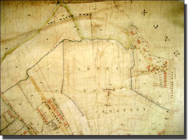
The Tithe Map of the Manor Road/Lordship Road area.
In 1846 Allerton, who later gave his name to Allerton Road, made a Tithe Map of Stoke Newington. There is a beautiful reproduction in the Hackney Archive on three large sheets. The small pictures which follow and show the area around Grazebrook School, are photocopies of this map, printed by kind permission of Hackney Archive.

1848 Tithe map
This fragment of Allerton’s Tithe Map shows how the Crooked Lane Field in Lady Abney’s 1734 map was straightened out so that the estate could be developed. By 1848 Lordship Road and Manor Road had been made, ready for the builders to move in. There were houses on one side of Lordship Road and Lot 96 was where the United Reform Church now stands and Manor Road Playgroup meets.
The site of Grazebrook Primary School is a little further along the road to the north.
1848 Tithe map continued
Manor Road continued round the top of Abney Park Cemetery and the Hackney Brook to Stamford Hill. This opened up the Stoke Newington Estate on both sides – to Stoke Newington High Street in the east and to Green Lanes on the west so that the Estate now had entrances from all four sides. This easy access would attract the builders and the future tenants.
The Estate owners rubbed their hands with glee. Houses are part of the land they stand on and the ground has to be rented every year. Instead of using their meadows to grow hay and feed dairy cattle, as they did in Lady Abney’s day, they would charge Ground Rents to the people who lived in the new houses. When the leases ended, the houses would become the ground landlord’s property and he/she would charge the next tenants even bigger ground rents in line with inflation.
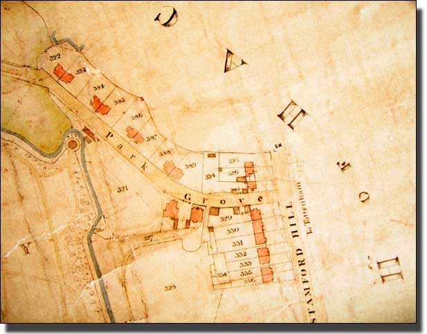
1848 Tithe Map of Park Grove
This detail shows that this part of the land, which was on Stoke Newington High Street and therefore easy to reach, was developed well before 1848. Park Grove acted as one entrance to the new Manor Road estate. As this was a Stoke Newington map, Stamford Hill is left blank. It was being developed, but had nothing to do with Stoke Newington tithes.
At the same time (1846) a Parish Map was published

The part of the 1846 Parish map of the area around Grazebrook Primary
School

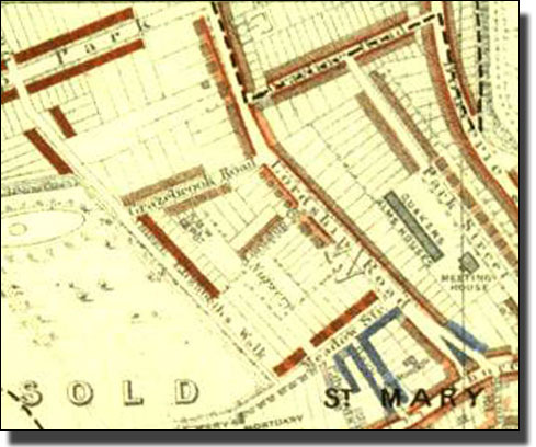
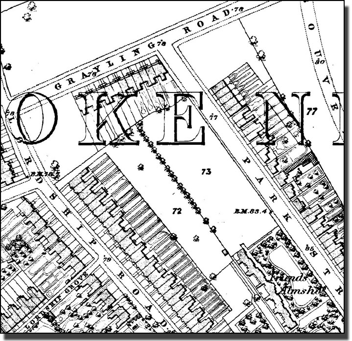
The neighbourhood of Grazebrook School in 1868
Manor Road had long been laid out to join Stoke Newington Church Street and Green Lanes, near the Manor House. The fields were marked out as building lots and numbered. By 1868 houses had been built all the way from Stoke Newington Church Street. Houses had been built on one side of Grayling road, but the larger ones on the corner had not yet been built. Houses around Lordship Grove had very large gardens and there seems to have been a Plant Nursery in Brook Road.
The Friends Meeting House and the Almshouses next door had been built in Park Street (now called Yoakley Road). There were still empty building lots north of Grayling Road, where only three or four houses had been built. Lot 13, which is now Yoakley Road, was still empty, but the land in general was filling up with houses.
The Booth London Poverty Maps
Charles Booth (not to be confused with General Booth of the Salvation Army) was a wealthy business man who refused to believe that a million Londoners lived in 'great poverty', as radical politicians claimed. He started a long survey to prove them wrong, the first really careful survey of how people lived and worked. He found in the end that the position was even worse than he had been told.
Booth published coloured maps of the streets of London showing their status. The survey took seventeen years and proved that the housing problem was even worse than he had been told.
How the Survey Was Compiled
The information was collected by teams of people who interviewed the local clergy, police, teachers, and others with particular knowledge of the local areas. One of the main sources of information was the School Board Visitors. Their original qualification was the ability to run faster than the children, and so catch truants, but they became far more than that, compiling unrivalled local knowledge. It was their duty to visit every house in every street and make notes on each family with children of school age. This began a few years before the children reached school age and continued until the last child in the family had left.
The Booth 1889 London Poverty map of the Grazebrook School area.
This small piece of the map shows a wide mixture of colours. Most of Stoke Newington was still quite prosperous. Meadow Street (now Lordship Terrace) had large houses coloured Red, with long gardens. Years later these gardens would be covered by the huge1933 blocks of flats. Lordship Road was completely built up but this end was coloured in Red and Pink. In Manor Road the Red houses held well-to do residents with at least one servant living in. In the Pink houses were working people with an altogether different from the poor working class. These were the foremen and supervisors: what Booth calls ‘the non-commissioned officers of the industrial army.’ Church Street was much the same but the area around Barn Street was poor. It was marked in Light Blue which means that the people were poor but not ‘in want’. Life was an unending struggle, but there were two lower grades of poverty than Light Blue.
Uses of the Booth Poverty Maps in this website.
Link To London School of Economics for Booth maps and documents

Grazebrook School site in1894
By 1894 the large houses on the corner of Manor Road and Grayling Road had been built. Yoakley Road was still called Park Street. Houses had been built on lot 13, and there were Almshouses where the modern blocks of Council flats now stand. They were called Friends Almshouses because they were built by The Friends (or Quakers) who were a very strong religious group in Stoke Newington for many years.
++OUTLINE THE PRESENT SCHOOL SITE

Grazebrook School area in 1914
Grazebrook School area in 1936
Bombing in the Second World War
This important map was made immediately after the Second World War by men riding round on their bicycles, looking at every damaged building and deciding how badly it had been bombed. Each house was graded and coloured according to the key shown above and the map became the basis of the Abercrombie Plan for the Rebuilding of London. This is one tiny part of it. It is a key map for understanding our present London landscape.
The map shows that a large bomb fell in Grazebrook Road (Purple). These houses were ‘ damaged beyond repair’ and the houses nearby (Dark Red) were ‘ seriously damaged, doubtful if repairable’. These seriously damaged houses included the site of Grazebrook School.
Other houses (Light Red) were ‘ seriously damaged, but repairable at cost’. In addition, almost every other house in the neighbourhood suffered ‘ Blast damage’ ( Orange or Yellow). Some of this may have been from other incidents but the rings of damage centred on the Purple in Grazebrook Road, show that this was the major incident, so the bomb must have been a very large one indeed.
For years the area must have been a large bombsite. Probably some older people remember playing on it as children.

Grazebrook School site on the 1939-45 Bombing Map
Colour Key References |
|||||
| Black -Total destruction | Orange - General blast damage, not structural | ||||
| Purple - Damaged beyond repair | Yellow - Blast damage, minor in nature | ||||
| Dark Red - Doubtful if repairable | O | V1 flying bomb | large circle | ||
| Light Red - Seriously damaged, but repairable at cost | o | V2 long range rocket. | small circle | ||
| There will be slight variations in the colours because the original maps are old and the colour balance on computer monitors will vary |
|||||
Uses of the Bombing Map on this website
The centre of impact seems to have been between the T and O in Newington (Purple beside Dark Red) and the damage spread from there. Even worse damage occurred in Bouverie Road (Purple) and all the houses between the two incidents suffered some form of blast damage. (Yellow).

Grazebrook School area in 1952
Schools have permission to use later maps (which are still in copyright) for educational purposes and may like to add them to their versions of this section. They cannot be added here of course.
The Google Aerial plan of the Grazebrook School site
Grazebrook Primary School
|
