The March of Bricks and Mortar
into Stoke Newington
[The development of Clissold Crescent: Part 1]
 |
The Earl of Darlington began to sell off the land south of Church Street in 1810. Part of this became Clissold Crescent. Click on the map for a description of this original sale and the way Cubit developed Albion Road. |
The Willows Estate from about 1823 to 1891
This is the story of how a small estate in Stoke Newington, called The Willows, grew into a large pleasure ground for a rich man and then was sold off for speculative house building when London began to expand into the suburbs.

(Photograph by permission of Hackney Archive)
The 1848 Tithe map of what was to become the Willows Estate.
This was sold on the death of Mr. Alexander,
but in 1848 he owned only The Willows.
This is the story of the development and sale of the final 10 acre estate
The 1848 Tithe Map shows 'The Willows' as a large house in Stoke Newington Church Street. It stood by Paradise Bridge, which carried the road over the New River. To the rear there were almost empty fields along Park Lane (which we now call Clissold Crescent).
The Willows was the last house in the terrace, and stood next to Warwick House (which was owned by Hanbury, the partner of William Allen in Allen and Hanbury, the pharmaceutical Company). CLICK FOR BIOG OF WILLIAM ALLEN
|
This is the view from the front gate of The Willows (Postcard [Derek Baker]) |


The Willows was the last house in the terrace, and stood next to Warwick House. The Willows stood at the corner of Church Street and Park Street, so its outlook was precisely the one shown in the upper picture, with Clissold House in the background. At the front gate was Paradise Bridge, where the New River flowed across the Church Street and, on the west, was Park Lane Bridge, where the river began to flow past Newington Hall. Most Paradise Row houses had big gardens eighty or a hundred feet long.
In 1848 Mr Alexander bought The Willows and the small piece of land between the New River and the corner of Clissold Crescent. He added to his estate over the years as more fields were purchased and a number of houses built or purchased. By 1891, when he died and his estate was sold, it stretched the full length of Clissold Crescent and included houses in Willow Walk (Aden Terrace) and Thistleton House, in Clissold Road.
In the middle of the Nineteenth Century, Paradise Row and all that end of Stoke Newington Church Street, must have been one of the most desirable places to live in, in the whole of North London. On the other side of Stoke Newington Church Street was Clissold Park, already fringed with mature trees and with the New River running quietly through its grounds. The river ran parallel to the road, with shady walks beside the water, then crossed Church Street at Paradise Bridge, flowed under Park Lane Bridge nearby and ran down past Newington Hall to cross Green Lanes, down the centre of what is now Petherton Road, and so into Islington.

The New River passing under Park Lane (later Clissold Crescent) Bridge
(Used postcard 1905 [Derek Baker])
New River Park Lane Bridge.(Clissoldm Cres.)1905.jpg
Wealthy people could drive back from their banks or factories in the City to semi-rural surroundings. The houses were in warm red brick, with long gardens behind. There were good schools for those who could pay the fees, fresh air for the sickly, peace for the retired.
INSERT HERE THE CENSUS MATERIAL FOR PARADISE ROW
1841 TO BE FOUND
1851
The Paradise Place census returns show the sort of people who could afford to live there in 1851.
The Heads of houses included:-
- A Tailor & Draper, aged 59;
- A Linen draper and silk mercer, 49;
- Retired surveyor, 64;
- Superintendent of Life Insurance Society, 76;
- Merchant, 46;
- Paradise Villa had a Barrister in practice, 37;
- Paradise Place continued,
- A Bill Broker, 48;
- Linen Merchant, 48;
- Retired wine merchant, 71;
- Auctioneer's wife, 39;
- Mahogany broker's wife, 43
- Wholesale draper, 69,
- Retired corn trader, 63,
- Gentleman, 62;
- Accountant, 72;
- Chemist, 55;
- Fund-holder, 68.
| 1 Glebe Place, | Retired officer East India Company, 54 | ||
| 2 | " | " | Gun manufacturer employing 150 men, 27, |
| 3 | " | " | Fund-holder, 61, |
| 4 | " | " | Widow of retired pattern designer |
Glebe field
Labourer and his wife
Four houses building
The Rectory, Archibald Wilson Taylor, Rector.
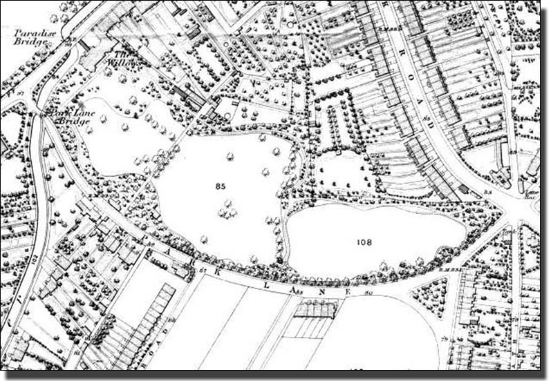
Park Street (now Clissold Crescent) from Church
Street to
Albion Road in the 1868 Ordinance Survey Map
Fortunately for us the 1868 map, which was the most detailed and expensive of all the Ordnance Surveys, shows every tree. They completely surround the estate, protecting it from the gaze of the general public. There were many mature trees, standing singly in lawns, but the surrounding screen protecting the estate is close packed with trees and underlying shrubberies. At the Clissold road corner there was a dense mass of woodland and even the private road is shrouded in trees. This road had its gatehouse on Clissold Crescent leading to the coach houses, stables, gardener's cottage, greenhouses and kitchen garden. All the activity connected with this was hidden from the family by a dense wedge of shrubberies and a line of trees.

What is now the Albion Parade Shopping Centre in 1888,
looking from the present Triangle towards Stoke Newington Church Street.
The picture was taken from what is now the bus stop.
The row of private houses on the right had their own front gardens. Later the Ground Floors were converted into the present row of shops on the south side of Albion Parade, and the gardens were concreted over as forecourts. The North side, which is now a row of eight shops, was still part of the dense mass of trees and shrubbery which surrounded the Willows estate and protected the privacy of the fortunate owner.
The 1868 map shows The Willows in Stoke Newington Church Street, with three large gardens, or paddocks running the length of Park Street, marked with their sale lot numbers. A narrow road divides the first two, but there is a gap in the tree line between the two, and they share the same sale number of 85. The third paddock is number 108, completely fringed with trees and shrubs. It might be thought to be separate, except that there is a narrow pathway through the trees at the top left corner. It too is part of the grounds of the house.
At the time of the 1868 map the houses on the east side of Albion Road would have been about thirty years old. Burma Road was being built and there were four houses on the south side of Park Lane, between Winston Road and Springdale Road.

Kennaway Hall
Mr Alexander demolished The Willows and rebuilt on the site. This new building was later called Kennaway Hall. It is built in the Victorian Gothic style, which was fashionable at that time. On the left, in white stucco, is Warwick House. The original Willows House which is shown on the 1848 Tithe map was built touching Warwick House and was much smaller than Kennaway Hall. It seems probable that it looked like Warwick House. It was this building which was sold as The Willows in the 1891 Sale and became Kennaway Hall. I am not clear when the house was given that name, or by whom.

The Dining Room, Kennaway Hall
Mr. Hanbury lived in Warwick House. Hanbury was the Hanbury of "Allen and Hanbury" the pharmaceutical firm. For details of the firm of Allen and Hanbury, click here. (Not written yet)

The Study: Kennaway Hall

Kennaway Hall
It was a very large house indeed, with eleven bedrooms, and at the end of the century it was in use as a Ladies Home, or Missionary College, occupied by the Mildmay Mission. Whether it was built for this purpose, or was originally a private house, is not explained in the brochure. It was sold by private treaty, so it seems likely that the Mildmay mission bought it before the auction.


The view up Paradise Row, north of Kennaway Hall
The Story Continues in Part 2 By 1891 when Mr. Alexander, the owner, died the sale document was impressive. It describes a ten acre site and each of the various houses in detail and, at the end, was this coloured plan, now lying in Hackney Archive as bright as when it was first printed. You will find details on this sale and the continuing story of the development of Clissold Crescent by clicking on the map. |
 |
|